|
The Copper Canyon is truly one of the Western Hemisphere's great scenic and cultural journeys, the Sierra Tarahumara (Copper Canyon) belongs on the wish list of most every traveler. It is fast becoming Mexico's most popular "soft-adventure" attraction while also catering to hardcore backpackers, day hikers, mountain bikers, bird watchers, historians, and naturalists. It is also one of Mexico's most popular attractions for senior citizen vacationers.
 |
On a map the trek looks like a simple train trip between the Chihuahua, capital city of the state by the same name and the small city of Los Mochis in Sinaloa near the Sea of Cortez. In fact this journey showcases not only one of the world's great engineering feats, but also some of the world's most awesome scenery and the most primitive aboriginal culture left in North America. |
The name, "Copper Canyon" is used as a general reference to the Canyons. A more proper name might be "Sierra Tarahumara", since the Copper Canyon (Barranca del Cobre in Spanish) is but one of six massive gorges in the area covering 64,000 sq. kms (25,000 sq. miles). Also of note is the fact that copper was never mined in great quantities here. The term refers to the copper/green colored lichen that clings to the canyon walls. Furthermore, a main draw to the region is the rich indigenous Tarahumara culture.
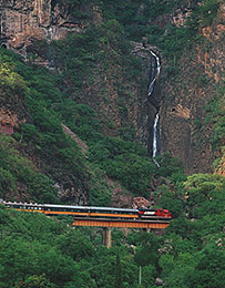 |
The journey is special on several fronts, not the least of which is the incredibly ingenious train route. The Chihuahua al Pacifico Railroad carries riders from sea level to over 2,400 meters (8,000 feet) when traveling west from the agricultural city of Los Mochis, through coastal plains, up and over the Sierra Madre mountain range before descending to the city of Chihuahua 655 kms (393 miles) away. Along with the many bridges and tunnels which are crossed, there's even a 360 degree loop over itself at Km. 592.
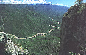
The region's geological splendor is equally remarkable. The Sierra Tarahumara is in fact a maze of 200 gorges which combine to form a series of six massive, interconnected canyons, or barrancas. |
This canyon system is four times larger than the Grand Canyon in the United States. Four of its six canyons are deeper than the Grand - some by over 1,000 feet.
An incredible variety of ecosystems further distinguish the region. Highlands are home to snow-covered mountain peaks, sparkling lakes, and enormous stands of old-growth Poderosa pine and oak. The area's plunging gorges sprout wild rives, towering waterfalls and sub-tropical forests. Semi-arid coastal plains to the west support large sugar cane and rich vegetable farms, while valleys to the eastern (Chihuahua) region are home to peach and apple orchards and vast grasslands.
|
Wildlife is equally varied. 290 species migratory and indigenous birds, several large mammal species (bear, deer, large cats), and numerous reptiles (87 species) inhabit the area.
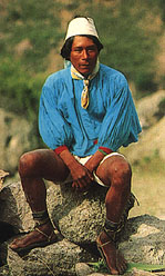
Complimenting the area's awesome natural attractions is the equally interested Tarahumara (Raramuri, as they called themselves) indian culture. These semi-nomadic people number around 50,000, many are predominately cliff and cave dwellers eking out a meager substance from simple farming, ranching, and handicrafts. Men are noted for their remarkable running ability, competing in grueling races that stretch non-stop for over 100 miles at times. |
|
Visitors can choose two ways to spend their time in the Copper Canyon region. Most visitors stick to the rail route, making stops along the way for day hikes around the canyon rim. The second option involves venturing into the canyons. This option requires more planning, stamina, and an adventurous spirit. However, canyon visits are often the most rewarding, as it is here the region's awesome treasures come alive.
The best time to visit the area is during the fall, after summer rains have revived the area's vegetation, and rivers and falls are running full. Spring also offers a pleasant climate throughout the canyons. Also take into account the area's two distinct climatic zones: alpine in the highlands (mild temperatures April-October with rain showers July-September; colder November-March with some snowfall), and subtropical in the canyon bottoms (very hot and humid May-July; warm temperatures the rest of the year).
The directory covers the canyon region of the Sierra Tarahumara (Copper Canyon) of northwest Mexico, and the railroad line to the Sea of Cortez as listed below:
Copper Canyon Area
One of Mexico's most breathtaking & isolated natural areas. Excellent for hiking, adventure & discovery. Includes many small towns such as Batopilas, Unrique, and the supply center of the region, Creel.
El Fuerte
A quaint former colonial capital of Sinaloa, now it is famous for it's fresh water fishing & departure point for the Copper Canyon. Historical haciendas are available for lodging.
Los Mochis
The beginning point for the Chihuahua al Pacifico railroad, one of the world's most awe-inspiring train trips. West to east provides the best views & scenery. Los Mochis is also close to the mainland ferry terminus from Baja California, Topolobampo.
The directory covers the canyon region of the Sierra Tarahumara (Copper Canyon) of northwest Mexico, and the railroad line to the Sea of Cortez as listed below:
Other Locations
Please consult "Nearby Places" on the side menu.
|